If you walk through the Plum Run valley today, it feels peaceful.
Water moves quietly through grass and stone. Visitors pass between Devil’s Den and the Wheatfield, often without giving the stream a second thought. Yet this modest ribbon of water runs through some of the fiercest ground at Gettysburg. Before the battle, it watered farms. During the battle, it shaped death and survival. After the battle, it became part of a preserved national landscape inside Gettysburg National Military Park.
To understand Plum Run, we have to begin before the smoke.
Before the Battle: Working Ground
In 1863, Plum Run flowed through active farmland in Cumberland Township. The valley between Big Round Top and the ridges nearer town was divided into privately owned farms, each marked by fences, lanes, orchards, barns, and springhouses.
The Slyder family farmed land near the base of Big Round Top, where Plum Run wound through meadow and pasture. John and Catherine Slyder’s farmhouse stood within sight of the valley floor. Their crops were growing in July 1863.
North of them lay the Rose Farm, owned by George Washington Rose. His fields bordered the Wheatfield, and Plum Run shaped the damp low ground near his property.
Farther east stood the Trostle Farm near the junction of Wheatfield Road and Emmitsburg Road. The Trostle family’s fields sloped toward the stream. Their barn and house overlooked land that would soon erupt in artillery fire.
On higher ground above the swale stood the Weikert Farm. George Weikert’s house would later serve as a field hospital.
Westward, within the broader Plum Run watershed, the Henry Spangler Farm stretched toward Seminary Ridge.
These were not symbolic places. They were family investments. Mortgages were paid from harvests. Livestock depended on water from the stream. Plum Run was practical. Necessary. Ordinary.
Until July 2.
July 2, 1863: The Valley Turns Violent
On the afternoon of July 2, Confederate forces under Longstreet’s First Corps attacked the Union left. Fighting erupted across ground that hours earlier had held wheat and orchard grass.
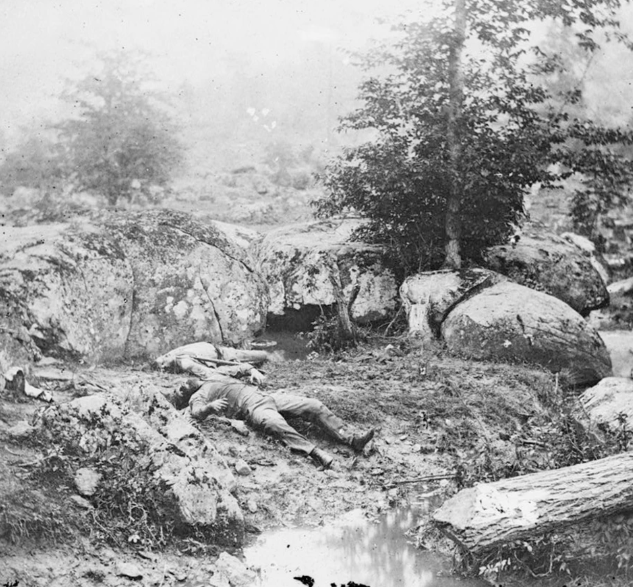
The valley beside Devil’s Den — rocky, uneven, and tangled — became a killing ground. Today it is known as the Slaughter Pen. Plum Run flowed through the lowest ground of that broken terrain.
Soldiers from the 4th Texas, part of Robertson’s Texas Brigade attacking through Devil’s Den, later described the enemy stationed among the rocks and pouring fire at them from every direction.
That is still what the ground looks like today. This was not smooth maneuvering across open pasture. It was climbing, slipping, squeezing through rock corridors under musket fire.
Another Confederate recalled that the rocks were piled in wild confusion, and from everywhere there seemed to be firing. It was intimate fighting. Close. Chaotic.
North of Devil’s Den, near Plum Run’s course, the Trostle farm became one of the crisis points of the battle. Captain John Bigelow’s 9th Massachusetts Light Artillery made a desperate stand there. In later years, Bigelow wrote that their retreat was terrible business.
That retreat carried Union soldiers back across the Plum Run low ground toward Little Round Top and Cemetery Ridge. Days later, photographs showed dead horses still lying near the Trostle position — grim evidence of how exposed the ground had been.
The stream itself did not choose sides. But its geography mattered. It marked the lowest swale between ridges. It shaped artillery placement. It forced infantry to descend and then climb again under fire.
Names That Stuck
After the war, veterans returned and named places.
The rocky valley near Devil’s Den became widely known as the Slaughter Pen. The name appears in early battlefield interpretation and remains in use today.
The nickname “Bloody Run” also entered popular memory. Like many battlefield labels, it reflects how people remembered what they experienced. Whether the water literally ran red or whether the phrase grew in retelling, the stream’s identity changed after July 1863. Veterans would later recall wounded men crawling to Plum Run’s edge to drink and dying on its banks.
Plum Run was no longer just drainage through farmland. It had entered American memory.
From Private Farms to Public Landscape
In the decades after the battle, the Plum Run valley slowly transformed from private land to preserved battlefield.
By the late nineteenth century, the Gettysburg park commission was building roads and bridges across the wet ground. Infrastructure was required to make the landscape accessible to visitors. Over time, the Rose, Weikert, Trostle, and Spangler farms were acquired and incorporated into what became Gettysburg National Military Park.
Modern preservation goes beyond buildings. The stream itself requires management. The National Park Service monitors erosion, maintains bridges, and manages wetland conditions — including beaver activity that can alter water flow.
In recent decades, land along Plum Run near Big Round Top has been added to the park boundary. Partnerships involving the Gettysburg Foundation and the American Battlefield Trust have helped protect additional acreage associated with the stream corridor.
The same water that once supplied livestock now flows through carefully preserved historic ground.
A Quiet Stream with a Loud History
Plum Run does not dominate the skyline at Gettysburg.
But it runs through the heart of July 2. It shaped fences and harvests. It shaped retreat and advance. It flowed through smoke and gunfire.
Stand there today and listen. The water sounds calm.
In 1863, it moved through rock, chaos, and the desperate scrambling of men trying to survive.
Plum Run is small.
Its story is not.
Leave a Reply